Différences entre les versions de « Publications »
De
| Ligne 30 : | Ligne 30 : | ||
<small><font color="grey">''Overview of our coherent multi-layer landscape synthesis: given a set of input exemplars, our method automatically creates a high-resolution consistent and coherent multi-layer terrain model from a low-resolution elevation model by matching input patches with the nearest dictionary atoms.''</font></small> | <small><font color="grey">''Overview of our coherent multi-layer landscape synthesis: given a set of input exemplars, our method automatically creates a high-resolution consistent and coherent multi-layer terrain model from a low-resolution elevation model by matching input patches with the nearest dictionary atoms.''</font></small> | ||
| − | Abstract: '' | + | Abstract: ''Authoring virtual terrains presents a challenge and there is a strong need for authoring tools able to create realistic terrains with simple user-inputs and with high user control. We propose an example-based authoring pipeline that uses a set of terrain synthesizers dedicated to specific tasks. Each terrain synthesizer is a Conditional Generative Adversarial Network trained by using real-world terrains and their sketched counterparts. The training sets are built automatically with a view that the terrain synthesizers learn the generation from features that are easy to sketch. During the authoring process, the artist first creates a rough sketch of the main terrain features, such as rivers, valleys and ridges, and the algorithm automatically synthesizes a terrain corresponding to the sketch using the learned features of the training samples. Moreover, an erosion synthesizer can also generate terrain evolution by erosion at a very low computational cost. Our framework allows for an easy terrain authoring and provides a high level of realism for a minimum sketch cost. We show various examples of terrain synthesis created by experienced as well as inexperienced users who are able to design a vast variety of complex terrains in a very short time. ''<BR><small>[Get the paper [https://hal.archives-ouvertes.fr/hal-01583706/ '''here'''] ]</small></li><BR> |
<li>G. Guingo, B. Sauvage, J-M. Dischler, M-P. Cani, ''Bi-Layer textures: a Model for Synthesis and Deformation of Composite Textures'', Eurographics Symposium on Rendering, 2017.</li><BR> | <li>G. Guingo, B. Sauvage, J-M. Dischler, M-P. Cani, ''Bi-Layer textures: a Model for Synthesis and Deformation of Composite Textures'', Eurographics Symposium on Rendering, 2017.</li><BR> | ||
| Ligne 40 : | Ligne 40 : | ||
</ul> | </ul> | ||
| + | |||
| + | |||
| + | We present an efficient method for generating coherent multi-layer landscapes. We use a dictionary built from exemplars to synthesize high-resolution fully featured terrains from input low-resolution elevation data. Our example-based method consists in analyzing real-world terrain examples and learning the procedural rules directly from these inputs. We take into account not only the elevation of the terrain, but also additional layers such as the slope, orientation, drainage area, the density and distribution of vegetation, and the soil type. By increasing the variety of terrain exemplars, our method allows the user to synthesize and control different types of landscapes and biomes, such as temperate or rain forests, arid deserts and mountains. | ||
| + | |||
</div> | </div> | ||
Version du 28 mai 2018 à 16:51
Publications
You will find on this page all scientific publications related to HDWorlds project.
2018
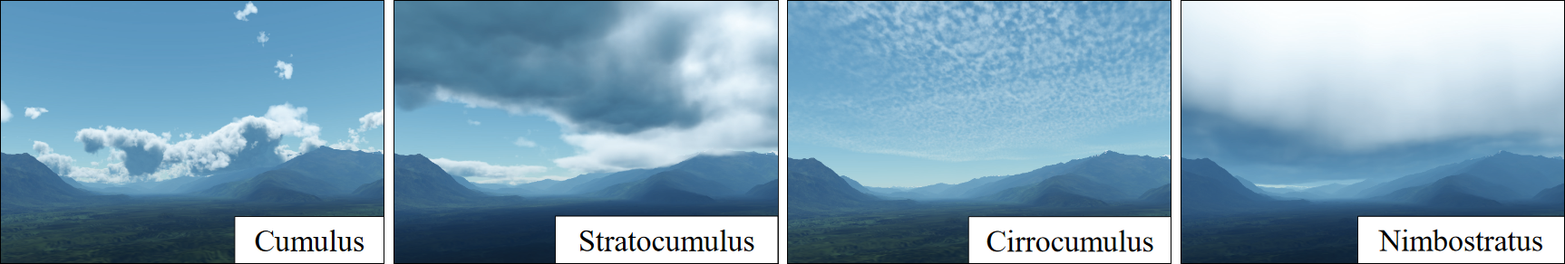
- Procedural Cloudscapes
A. Webanck, Y. Cortial, E. Guérin, E. Galin
Computer Graphics Forum, 37(2), Eurographics, 2018.

Our procedural cloudscape model allows to represent different types of clouds.
Abstract: We present a phenomenological approach for modeling and animating cloudscapes. We propose a compact procedural model for representing the different types of cloud over a range of altitudes. We define primitive-based field functions that allow the user to control and author the cloud cover over large distances easily. Our approach allows us to animate cloudscapes by morphing: instead of simulating the evolution of clouds using a physically-based simulation, we compute the movement of clouds using key-frame interpolation and tackle the morphing problem as an Optimal Transport problem. The trajectories of the cloud cover primitives are generated by solving an Anisotropic Shortest Path problem with a cost function that takes into account the elevation of the terrain and the parameters of the wind field.
[Get the paper here ]
2017
- Interactive Example-Based Terrain Authoring with Conditional Generative Adversarial Networks
E. Guérin, J. Digne, E. Galin, A. Peytavie, C. Wolf, B. Benes, B. Martinez
Transactions on Graphics (Proceedings of Siggraph Asia), 2017.

Overview of our coherent multi-layer landscape synthesis: given a set of input exemplars, our method automatically creates a high-resolution consistent and coherent multi-layer terrain model from a low-resolution elevation model by matching input patches with the nearest dictionary atoms.
Abstract: Authoring virtual terrains presents a challenge and there is a strong need for authoring tools able to create realistic terrains with simple user-inputs and with high user control. We propose an example-based authoring pipeline that uses a set of terrain synthesizers dedicated to specific tasks. Each terrain synthesizer is a Conditional Generative Adversarial Network trained by using real-world terrains and their sketched counterparts. The training sets are built automatically with a view that the terrain synthesizers learn the generation from features that are easy to sketch. During the authoring process, the artist first creates a rough sketch of the main terrain features, such as rivers, valleys and ridges, and the algorithm automatically synthesizes a terrain corresponding to the sketch using the learned features of the training samples. Moreover, an erosion synthesizer can also generate terrain evolution by erosion at a very low computational cost. Our framework allows for an easy terrain authoring and provides a high level of realism for a minimum sketch cost. We show various examples of terrain synthesis created by experienced as well as inexperienced users who are able to design a vast variety of complex terrains in a very short time.
[Get the paper here ] - G. Guingo, B. Sauvage, J-M. Dischler, M-P. Cani, Bi-Layer textures: a Model for Synthesis and Deformation of Composite Textures, Eurographics Symposium on Rendering, 2017.
- G. Cordonnier, E. Galin, J. Gain, B. Benes, E. Guérin, A. Peytavie, M.P. Cani, Authoring Landscapes by Combining Ecosystem and Terrain Erosion Simulation, SIGGRAPH, 2017.
[Get the paper here ] - O. Argudo, C. Andujar, A. Chica, E. Guérin, J. Digne, A. Peytavie, E. Galin, Coherent multi-layer landscape synthesis, The Visual Computer, 2017.
[Get the paper here ]
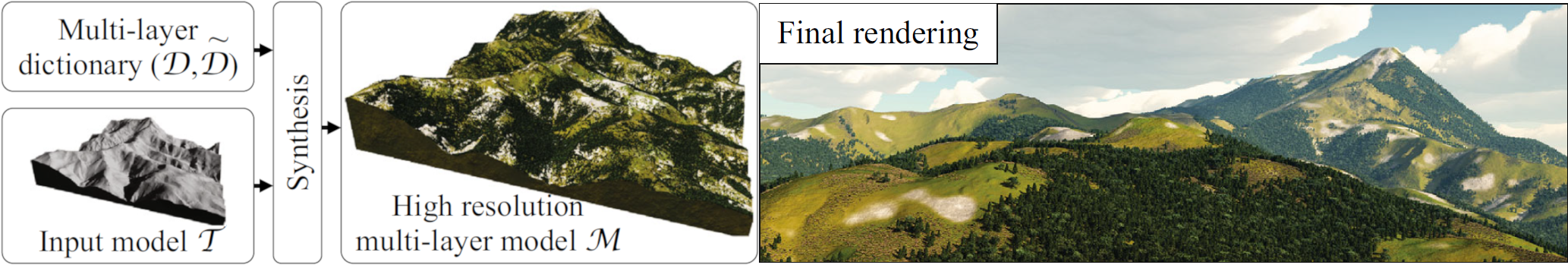
We present an efficient method for generating coherent multi-layer landscapes. We use a dictionary built from exemplars to synthesize high-resolution fully featured terrains from input low-resolution elevation data. Our example-based method consists in analyzing real-world terrain examples and learning the procedural rules directly from these inputs. We take into account not only the elevation of the terrain, but also additional layers such as the slope, orientation, drainage area, the density and distribution of vegetation, and the soil type. By increasing the variety of terrain exemplars, our method allows the user to synthesize and control different types of landscapes and biomes, such as temperate or rain forests, arid deserts and mountains.
